
Today, I want to share a useful resource I found while learning about Open-Source Intelligence. Sofia Santos has a blog with OSINT exercises for readers to complete. Currently, there are 31 exercises available, each with different levels of difficulty.
This year I decided to polish my geolocating skills. This was perfect for me, but there are other options available, such as GeoGuessr, if you are more into that kind of approach. I plan to do all of the exercises starting from the first one and working my way up.
OSINT Exercise #001
As you can see from the screenshot below, to complete this exercise we are only provided with a tweet that contains a picture and a short paragraph. There are two keywords that I spotted there. The first keyword is “morning” and the second one is “Kiffa”. This is the location where the picture was taken.
Next, I noted the shadows. This is when the “morning” keyword came in handy. Since the sun rises in the east and sets in the west, this immediately tells me that the picture was taken facing south.

Now that we have figured out which direction we are facing, let’s dive into what can be seen in the picture. The first thing that caught my attention was the buildings on each side of the picture, and then the treetop behind the building on the right.
Looking more carefully, you can see that the soil is very dry and does not seem to have a ton of plants nearby. However, you can see what looks like a tree line in the background. The tree line has a road that cuts right through it and curves slightly to the right. At this point I felt more comfortable to try and find it on Google Earth.
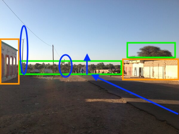
I searched for Kiffa and adjusted the map orientation so that it would be facing south. I found an area that seems to have a ton of trees towards the south and has a long road that matches what we saw in the original picture. If this was the right location, it could not be too far from that green area.

I started looking for buildings with trees right behind them and came across this location. It is close to the tree line, has buildings on both sides of the road, with a tree right behind the right-side building.

Upon closer inspection I decided to go through the historical images that were available and noticed a “T” shape. Looking back at the original picture, I strongly believe these are the power lines that I circled in blue before.

Task: “Please identify the coordinates of where the photo was taken.”
Solution: The yellow star shows where I think the photographer was standing at the time of the picture. With that, the location coordinates would have to be around: 16°36’33″N 11°23’52″W
Discover more from Cyber-Jot | Learn Cybersecurity & OSINT
Subscribe to get the latest posts sent to your email.
Leave a Reply